Where Prestige Kodagurki sits
Kodagurki is a village in Devanahalli taluk of Bengaluru Rural district, pincode 562110, at an elevation of roughly 935 metres, about 6 km from Devanahalli town. It is reachable off NH-44 (Bellary Road) — the north-south national-highway spine that feeds Kempegowda International Airport — with the NH-648 and STRR alignments threading the wider belt. The address places the township firmly on the airport growth corridor, north of the city core, within the radius of the corridor's forward-looking jobs and infrastructure engine.
Provisional location note: No official geo pin has been published for Prestige Kodagurki. This microsite uses a provisional pin on the Kodagurki / Devanahalli belt (approximately 13.2420 N, 77.7180 E). The exact site coordinates, the two-parcel boundaries and the address will be confirmed on the official launch documentation and phase-wise RERA registration.
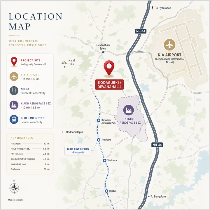
Connectivity — roads, ring roads, transit and the airport
Prestige Kodagurki's connectivity is built on NH-44 and a strong forward pipeline of ring roads and transit.
| Connectivity node | Approximate distance / detail |
|---|---|
| NH-44 (Bellary Road) | Primary spine — the north-south national highway feeding the airport and the city core |
| Kempegowda International Airport (BLR) | Short drive north via NH-44 — the Devanahalli belt sits ~12–15 km from the terminal |
| Devanahalli town | ~6 km — taluk headquarters, civic and daily-convenience base |
| Satellite Town Ring Road (STRR / NH-948A) | Threads the Devanahalli belt — regional ring connectivity to Doddaballapur, Hoskote and the satellite-town ring |
| Namma Metro Blue Line (airport line) | Under construction along the KR Puram–airport alignment; the corridor's largest forward transit catalyst |
| NH-648 | Secondary highway linking the belt eastward |
| Hebbal / city core | ~30–35 km south via NH-44 — the established city gateway |
| Outer Ring Road (ORR) / Manyata | Accessible south via NH-44 and Hebbal |
NH-44 (Bellary Road) is the corridor's backbone — a six-lane national highway with elevated and grade-separated sections that keep the drive to the airport and toward Hebbal efficient. For a resident, the airport is a short run north, and the city core is reachable south via the same spine. The Satellite Town Ring Road (STRR / NH-948A) is the belt's regional connector, linking the Devanahalli corridor to Doddaballapur, Hoskote and the wider ring of satellite towns without routing through the congested city core — a peripheral high-capacity axis that improves the address's regional reach.
The forward infrastructure pipeline is the corridor's re-rating story. The Namma Metro Blue Line (the airport line) is under construction along the KR Puram–airport alignment, connecting the airport to the city through KR Puram, Hebbal and Nagawara; when the airport stretch commissions, it becomes the single largest forward transit catalyst on the belt. Every operational metro extension on a Bengaluru corridor has historically compressed drive-to-station times and lifted rental and resale comparables within a year of commissioning — and Kodagurki buyers position ahead of that event.
Employment — the airport economy, aerospace and the KIADB cluster
The corridor's employment case rests on the airport economy and the KIADB industrial cluster, a genuinely differentiated jobs engine from the city's IT belts.
| Employment node | Approximate distance / detail |
|---|---|
| Kempegowda International Airport (BLR) | Short drive — the airport economy: aviation, ground handling, MRO, logistics, hospitality |
| KIADB Aerospace Park & SEZ | ~3,000-acre aerospace and hardware cluster in the Devanahalli belt |
| Foxconn manufacturing facility | Major KIADB-belt employer scaling toward tens of thousands of jobs |
| Bengaluru Airport City / IFC | Emerging business, retail and financial district adjoining the airport |
| Devanahalli Business Park / IT investment region | Corridor employment node on the airport belt |
| Bengaluru Aerospace Park SEZ tenants | Aerospace, defence and precision-manufacturing units |
| Hardware / electronics manufacturing (belt) | KIADB industrial employment adjacent to the corridor |
The anchor is the airport economy — one of the few large employment engines in the country built around an international airport, spanning aviation, aerospace, MRO, logistics, hospitality and the emerging financial district. The KIADB Aerospace Park and SEZ, at roughly 3,000 acres, is the corridor's differentiated industrial cluster, and the Foxconn manufacturing facility is scaling into one of the belt's largest single employers. The emerging Bengaluru Airport City and International Financial District (IFC) adds a services and financial-employment layer adjoining the terminal.
Honesty flag: the highest-density IT employment still sits in the established Manyata, Whitefield and ORR clusters well to the south, not at Kodagurki's doorstep. The corridor's own on-site job density is airport- and manufacturing-led and still building. Prestige Kodagurki is best read as a large-format township that taps the airport economy and the KIADB cluster, positioned ahead of the corridor's continued jobs build-out — rather than as a live-where-you-work IT precinct today.
Schools
The Devanahalli / airport belt's education infrastructure has matured alongside its residential growth, with more capacity arriving.
| School | Note |
|---|---|
| Stonehill International School | IB day-and-boarding international school on the airport road, ~19 km from the airport |
| Canadian International School | Established international-curriculum school on the North Bengaluru airport axis |
| Delhi Public School (DPS) | Well-known CBSE chain serving the Devanahalli / North Bengaluru belt |
| Akash International School | Reputed school in the Devanahalli belt |
| Vidyashilp / Ryan International (North Bengaluru) | International and CBSE options within reach on the corridor |
| Oakridge / Mallya Aditi (North Bengaluru axis) | Premium schools reachable via NH-44 for a wider choice |
| Local CBSE & state-board schools (Devanahalli) | Serve Devanahalli town and surrounds |
For families, the corridor offers a workable mix of established international and CBSE schools today — Stonehill and Canadian International among the marquee names on the airport axis — with more capacity arriving. A 107-acre township like Prestige Kodagurki is also anticipated to carry a school provision within or adjoining the community, which addresses education on the doorstep for residents.
Hospitals and healthcare
| Hospital | Note |
|---|---|
| Akash Super Speciality Hospital | Multi-speciality care in the Devanahalli belt |
| Columbia Asia Hospital (North Bengaluru) | Established multi-speciality hospital on the airport axis |
| Aster / Manipal (North Bengaluru corridor) | Tertiary-care options reachable via NH-44 |
| Leena Multispeciality / local hospitals (Devanahalli) | Local multi-speciality and clinic provision |
| Airport-belt medical facilities | Serving the airport-economy and residential population |
Healthcare on the belt is anchored by Akash Super Speciality Hospital locally, with the broader North Bengaluru hospital network — including established multi-speciality names — a drive south on NH-44. As with retail, tertiary-care depth is still concentrating on the corridor, but the base is solid and growing with the residential population.
Retail, daily convenience and lifestyle
Retail is the corridor's still-maturing social-infrastructure leg. Organised large-format retail is concentrated toward the city and along the airport approach — Esteem Mall and the North Bengaluru mall belt to the south, and the Forum Mall Devanahalli and The Arcade at Brigade Orchards developments closer to the airport belt. Devanahalli town offers high-street retail, supermarkets and daily-convenience shopping, and the corridor's rapid residential growth is drawing organised retail steadily northward. A 107-acre township like Prestige Kodagurki also internalises much of the daily-convenience layer — with an anticipated retail high street within the township — which softens the corridor's retail gap for residents. Still, buyers who prioritise big-format mall and premium-dining access on day one should weigh the current drive honestly.
Beyond retail, the belt carries a genuine lifestyle draw: Nandi Hills, the historic hill station and weekend destination, sits within a short drive north of the corridor, and the Devanahalli belt's clubs, resorts and golf destinations add a leisure layer uncommon on the city's other growth corridors.
The honest corridor read
Devanahalli is an emerging corridor, not a mature one. Its appreciation record is strong and its infrastructure pipeline is substantial, but the day-one ecosystem — premium retail at scale, the full multi-speciality hospital depth, IT-scale job density — is arriving rather than fully realised, and rental yields today are modest. The corridor's value case is forward-looking: it rests on the airport economy, the KIADB Aerospace SEZ and Foxconn jobs cluster, the metro Blue Line and STRR, and the emerging Bengaluru Airport City and IFC. That is exactly the profile in which a large branded township outperforms — because it internalises the ecosystem the corridor hasn't finished building, and because entering ahead of the infrastructure re-rating captures the appreciation. Buyers should judge Prestige Kodagurki on that forward basis, and treat every pre-launch location detail as provisional until the official documentation and phase-wise RERA registration land. The master-plan and price pages together make the full case.
Prestige Kodagurki location FAQ
Common questions on where Prestige Kodagurki sits, the airport distance, the connectivity catalysts, the employment base and the schools and hospitals nearby.
Where is Prestige Kodagurki located?
At Kodagurki (pincode 562110), a village in Devanahalli taluk of Bengaluru Rural district, off NH-44 (Bellary Road) on the North Bengaluru airport belt, roughly 6 km from Devanahalli town and a short drive from Kempegowda International Airport.
How far is Prestige Kodagurki from the airport?
Kempegowda International Airport (BLR) is a short drive north via NH-44 — the Devanahalli belt sits roughly 12–15 km from the airport terminal. Airport adjacency, together with the KIADB Aerospace SEZ and the emerging Bengaluru Airport City, is the corridor's defining advantage.
What are the connectivity catalysts for the corridor?
NH-44 (Bellary Road) is the primary spine to the airport and the city. The Satellite Town Ring Road (STRR) adds regional connectivity. The Namma Metro Blue Line (the airport line) is under construction along the KR Puram–airport alignment — the corridor's largest forward transit catalyst. Together these form a substantial forward infrastructure pipeline.
What employment is near Prestige Kodagurki?
The airport economy — aviation, aerospace, MRO, logistics and hospitality — plus the KIADB Aerospace Park and SEZ (~3,000 acres), the Foxconn manufacturing facility (scaling toward tens of thousands of jobs), and the emerging Bengaluru Airport City and International Financial District. The corridor's jobs base is airport- and manufacturing-led and still growing.
What schools and hospitals are nearby?
Schools on the airport axis include Stonehill International School, Canadian International School, Delhi Public School and Akash International School. Healthcare is anchored by Akash Super Speciality Hospital, with the broader North Bengaluru hospital network reachable via NH-44. A 107-acre township is also anticipated to carry a school provision within or adjoining the community.
Talk to the Prestige Kodagurki team
Register your interest to receive the exact site coordinates, the two-parcel boundaries and the official location details for Prestige Kodagurki as soon as they are released, along with the launch timeline and price sheet.
Contact us